AEG Inland Empire Chapter
2026 Spring Field Trip Announcement Friday – April 24, 2026
A tour of the
Department of Water Resources Salton Sea’s
Species Conservation Habitat (SCH) Project
Overview of Salton Sea restoration efforts, with a focus on the planning, design, permitting, and construction challenges.
Hosted by
Mr. Vivien Maisonnueve,
State Water Resources Manager, California Department of Water Resources (DWR)
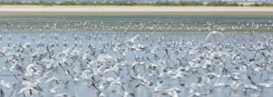
View of the Salton Sea, August 28, 2012. DWR/2012
Due to limited site access and safety considerations at the Salton Sea SCH Project site, participation will be limited to 15 attendees and will be available on a first‑come, first‑served basis for a Friday, April 24th, morning tour.
We will be limited to a few vehicles so carpooling will be required. If you are interested in attending and/or driving a carpool, please email us at aeginland@gmail.com .
- Meet near the site: 6140 Poe Road, Brawley, CA 92227
- The field trip will be from 9:00AM to 12:00PM (Noon). Please try to arrive 15 minutes early so that we can depart promptly.
- Here is a link for this google map:
-
We are supposed to be able to park our vehicles at this site. We will consolidate our group to three vehicles for the visit.
- Our host will supply PPE.
- Everyone must wear closed-toe shoes and clothes adapted to a dusty, sunny, and hot environment. Our host has water and bug repellent, but suggestsyou bring some too just in case.
- Bring your good humor and questions!
AEG Inland Empire
Mike Cook Memorial 2025 Spring Field Trip Announcement

Saturday – April 26, 2025
Lenwood Fault Zone Near Daggett Ridge
San Bernardino County, California
Right-Lateral Strike Slip Geomorphology and Geologic Hazards
Faults/Landslide/Rockfalls/Debris Flows/Miocene Pickhandle Fm

Date and Time: April 26, 2024. Approximately 9:00 am to 2:00 pm.
Location: Barstow Road (Hwy 247) & Powerline Road, South of Barstow, San Bernardino County, CA
Cost: Free, but your time and talent will be taken advantage of.
Trip will begin at the intersection of Barstow Road and Powerline Road in Stoddard Valley, approximately 10.2 miles south of Barstow:
MEET & GREET Coordinates: 34.75644N/117.00799W. Across the street from the Slash X Cafe.
The excursion is intended to be somewhat informal with the objective of highlighting the awesome geology of the northern Lenwood fault within the Eastern California Shear Zone, not to mention some seriously extreme geologic exposures and geologic hazards. 4×4 is usually not required, except for optional side trip.
To sign up, please contact Mark Spykerman at mspykerman@earthsystems.com. Deadline to RSVP is April 14, 2025. This trip will require a moderate amount of hiking ranging from easy to moderate difficulty.
Bring your own food & drink.
________________________________________________________________________
AEG Inland Empire Spring Field Trip Announcement
Saturday – April 20, 2024
Anza-Borrego State Park: Split Mountain to Sandstone Canyon
Subsiding Basin/San Andreas Rift Zone/Colorado River/Mega
Landslide/Rockfalls/Topples/Debris Flows/Faults/Imperial Fm/Palm Springs Fm.
ALL TO SEE AND MARVEL
( SEE THE BROCHURE )

Date and Time: April 20, 2024. Approximately 8:00 am to 2:00 pm.
Location: Split Mountain Road at Fish Creek Wash, Ocotillo Wells, San Diego County, CA
Cost: Free, but your time and talent will be taken advantage of.
Trip will begin at the intersection of Split Mountain Road and Fish Creek Wash, south of the Ocotillo Wells offroad recreation area: Coordinates: 33.03964N/116.09696W. Meet in the wash at the west side of the road and carpool from there through Split Mountain and on to Sandstone Canyon. Trucks and high clearance vehicles only. 4×4 usually not required. Each attendee needs to bring their own snacks and lunch.
The excursion is intended to be somewhat informal with the objective to highlight the awesome geology of the Anza-Borrego, not to mention some seriously extreme geologic exposures and geologic hazards. To sign up, please contact Mark Spykerman at mspykerman@earthsystems.com. Deadline to RSVP is April 13, 2024.
RSVP IS REQUIRED TO OBTAIN A GUIDE BOOK. Due to some topographic confinements, attendance will be limited to 30 maximum and carpooling in 7 to 8 vehicles.

2016 AEG Inland Empire Annual Spring Field Trip
Cost: Free, but your time and talent will be taken advantage of.Field trip will begin at the Stater Bros. shopping center at the northeast corner of State Street and Ramona Expressway in San Jacinto (There is a Starbuck!!!). The first stop will be a short hike up Massacre Canyon near Gilman Springs Road and Hwy 79 (Sanderson Avenue). Fascinating geology with some historical highlights. The tour will progress along the San Jacinto fault zone/Casa Loma strand, through the Cities of San Jacinto and Hemet, looking at the local fault expressions, impacts on roadway alignments and urban development.
Dr. Sally McGill of California State University San Bernardino
Ms. Janis Hernandez of the California Geologic Survey
Ms. Lisa Battiato of Geocon
Mr. Frank JordanThe excursion is intended to be somewhat informal with the objective to highlight the often subtle fault expression within urban development. An added attraction is the awesome San Jacinto Mountain range front along the northeast side of the City of San Jacinto to ponder the geology, faulting and landslides.Attendance will be limited to approximately six cars (approximately 24 people) for highway safety purposes. Drivers will be requested to arrive early to review planned stops. We will meet in San Jacinto and form a carpool to limit the total number of vehicles. Additional information will be provided at the next AEG meeting.To sign up, please contact Mark Spykerman at mspykerman@earthsystems.com. Deadline to RSVP is April 20, 2016.RSVP IS REQUIRED TO OBTAIN A GUIDE BOOK.
An Uplifting Experience: The Cajon Valley:
70 Ma of Textbook Geology
( SEE THE BROCHURE )
WHAT WILL WE SEE?
Structures:
- The collision point of the Pacific and North American plates
- Rotation of Transverse Range blocks with accompanying basin filling
- San Andreas Fault and the Squaw Peak Fault
- Timing and sequence of uplift of San Gabriel and San Bernardino blocks and developing geomorphologic features such as sag ponds and terraces Stratigraphy:
- Cosy Dell Formation: Cretaceous, with elasmosaurs, fish, crustaceans, and mollusks
- Vaqueros Formation, Oligocene-Miocene, with dolphins, fish, and mollusks
- Cajon Valley Formation, Miocene continental biostratigraphy
- Crowder Formation, Miocene continental biostratigraphy, relation to Mojave drainage patterns
- Phelan Peak Formation and the rise of the San Gabriel Mountains
- Shoemaker Gravels, Old Alluvium, the Brunhes/Matuyama Reversal, and rise of the San Gabriel Mountains.
- Early Pleistocene drainage and reversals and the development of the Mojave River
Wildomar Fault, Elsinore Graben
and Development Challenges,
and Vulcan Quarry (Corona)
Saturday, May 11, 2013
Wednesday May 8, 5pm is the RSVP deadline. Registration limited to the first 20 people and an RSVP is necessary to obtain a guide book.
Make your RSVP at: mspykerman@earthsys.com.
Geology and Geologic Hazards and Other Cool Stuff Along Portions of Hwy 18 and Hwy 330
Saturday, June 9, 2012
Address any questions to: mspykerman@earthsys.com.
Water and the San Bernardino Mountains
The Good, The Bad and The Muddy
RSVP by Wednesday April 6, 2011
The AEG Inland Empire Chapter’s Annual Field Trip will occur on Saturday April 9, 2011. The focus will be on Water and the San Bernardino Mountains The Good, The Bad and The Muddy. Will be looking at and discussing major water projects situated along the San Bernardino Mountain front from the Santa Ana River to Cajon Creek including Seven Oaks Dam, Inland Feeder Project, Devils Canyon Power Plant. Also we will be reviewing the impacts from winter storms and fire burn hillsides. Stops include: review of fault trenching at Plunge Creek; Highland mud damage; and Boulder Avenue Bridge washout from the December 22, 2010 flooding; Cal State San Bernardino flood basins; and a tour of the Devils Canyon Power Plant.
- Meeting Point is in the Highland Avenue Plaza – Wal*Mart parking lot on the NW corner of Highland Avenue and Boulder Avenue (near the Burger King). Meeting time will be at 7:30AM so we can begin at 8:00 AM.
- Pre-registration is required due to requirements for the tour of Devils Canyon Power Plant. Please notify Mark Spykerman (mspykerman@earthsys.com) or Mike Cook (MCook@kleinfelder.com) by April 6th if you are planning on attending.
2010 Annual AEG-Inland Chapter Field Trip & April Meeting
GEOLOGIC HIGHLIGHTS OF THE PERRIS PLAIN & TEMECULA/MURRIETA AREA
Saturday April 17
7:30 am to ~1:00 pm
Meet at 7:30 am at Menifee Market Place at Haun Road and Newport Road (TG Page, 868 E3). Staging area in parking lot in front of Breakfast Club.
Contact Mark Spykerman at mspykerman@earthsys.com; list the number field trippers.
2009 AEG-Inland Empire Annual Field Trip
HYDROGEOLOGY OF THERMAL SPRINGS IN THE PALM SPRINGS AREA
– INDIAN CANYONS & AGUA CALIENTE HOT SPRING
Courtesy of the Aqua Caliente Band of Cahuilla Indians


| WHEN: | MARCH 14, 2009 |
| WHERE: | PALM CANYON, ANDREAS CANYON, AND AGUA CALIENTE HOT SPRING, PALM SPRINGS, RIVERSIDE COUNTY, CALIFORNIA |
| SCHEDULE: | Meet at 7:30 am at Agua Caliente Spa Resort Casino in Palm Springs located at northeast corner of East Tahquitz Canyon Way and Indian Canyon Drive (TG Page, 786 E2). Staging area in parking lot at northwest corner of Spa and Resort (Entrance at Andreas Road and NB Indian Canyon Drive)
General Schedule Of Trip:
|
2008 AEG-Inland Empire Annual Field Trip
The Emerson Fault, 16 Years Later
 |
 |
 |
| WHEN: | APRIL 5, 2008 |
| TIME: | 8:00 AM TO 2:00 PM (After 2:00 pm, participants are free to roam the area on your own) |
| WHERE: | JOHNSON VALLEY OHV AREA, SAN BERNARDINO COUNTY, CALIFORNIA |
| SCHEDULE: | Meet at Soggy Dry Lake OHV staging area off of Bessemer Mine Road: |
Directions to Staging Area:
|
|
| NOTE: Vehicle access may be restricted to 4×4’s. Entry road to Soggy Dry Lake OHV area is rough but accessible to cars (go slow). Bessemer Mine Road from Soggy Dry Lake to Emerson fault area generally passable for cars (trucks and 4×4’s recommended). Trail off Galway Lake Road to area of maximum fault rupture is 4×4 recommended due to loose sand in wash. We recommend that participants truckpool at the staging area to reduce the overall vehicle traffic. ATV’s are welcome.
Please RSVP by April 2, 2008 to Mark Spykerman at mspykerman@earthsys.com. List number of field trippers to attend please. Bring your own lunch and refreshments. Select drinks will be provided by AEG.
|
|


|
Pushawalla/Thousand Palms SAF Field Trip |
|
This field trip to see landforms and fault trenches near the San Andreas fault was held on Saturday April 22, 2006. It was led by Mark Spyckerman and Rick Gundry. The chapter plans to run several, small, one-day field trips throughout the year. |
|